Angkor Archaeological Park Overview
Angkor Archaeological Park Overview
Stretching over some 400 square kilometers, including forested area, Angkor Archaeological Park contains the magnificent remains of several capitals of the Khmer Empire of the 8th to the 14th centuries. It is the largest pre-industrial city in the world. The most famous are the Temple of Angkor Wat and, at Angkor Thom, the Bayon Temple with its countless sculptural decorations. Within its vicinity, there are several temples built at differently, usually by a reign of Khmer Kings. Each King, from 800 to 1400 AD had built one or more temples and dedicate them to deity Hindu gods or their parents.
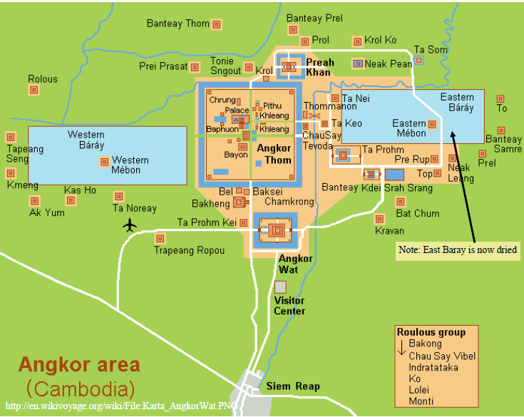
Angkor Archaeological Park was declared a UNESCO World Heritage site in 1992. At the same time, it was also placed on the List of World Heritage in Danger due to looting, a declining water table, and unsustainable tourism. UNESCO has now set up a wide-ranging program to safeguard this symbolic site and its surroundings. We will describe some of temples to give you insight of the architecture, when and by whom it was built. Use the map below as a reference. They can be reached by car or motorcycle called tok-tok with small fare.

The Angkor Era: From Kingdom to Empire
The Angkorian period span more than 600 years from 802 AD to 1432 AD. During this incredible period, hundreds temples of Angkor were built, many kingdoms were consolidated as a Khmer Empire that became one of the great powers in Southeast Asia.
The ancient Khmer culture at the time of its apogee (802-1327) is characterized by some of the key developments:
- Monarch is a head of imperial state
- Khmer Capital is always based in Angkor (Temple City)
- Hinduism/Mayahana Buddhism is state religion
- Worship of Linga
- Prasats (temples) are house of gods, arranged in block of stones supported by stepped pyramids
- Massive and extensive public waterworks (canals, moat, reservoirs)
- Network of highways, causeways and masonry bridges
- Inscriptions in Sanskrit and Khmer


